IZItopo Viewer
Share your 3D projects with your clients
The cloud platform to visualize, annotate and share your point clouds and 360 panoramas with your clients. No installation required.
Powerful features
All the tools to present your 3D projects to your clients
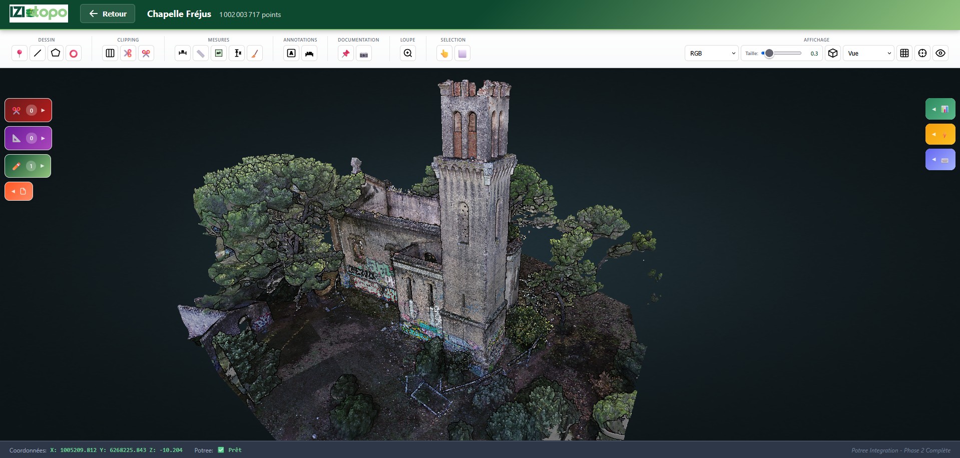
Point cloud visualization
Display billions of points in real-time with Potree technology. Smooth navigation on any device.
360 Panoramas
Integrate your panoramic photos and navigate through your projects as if you were there.
Annotation tools
Draw 3D points, lines and polygons directly on the cloud. Add measurements and comments.
Clipping Boxes
Clip your cloud to isolate specific areas. Perfect for presenting details to your clients.
Secure sharing
Share your projects via a simple link. Manage access rights per user.
DXF Export
Export your annotations in 3D DXF format for import into your CAD software.


How does it work?
Upload
Import your point cloud and panoramas from IZItopo Desktop
Annotate
Add points, lines, areas and comments directly in 3D
Share
Send a secure link to your clients, they view without installation
Who is it for?
Client project presentations
Remote site collaboration
Survey archiving and consultation
Civil engineering documentation
Work progress monitoring
IZItopo Viewer Pricing
Plans adapted to the size of your projects
Free
Discovery
Limits
- 10 GB storage
- 2 projects
- No sharing
Included
- 3D Viewer + Navigation
- Measurements (distance, area)
- Basic vector drawing
- 360 Panoramas
- Clipping boxes
- DXF Export
Standard
Freelancers
or €39/month · 1 year commitment
Limits
- 200 GB storage
- 20 projects
- 2 simultaneous viewers
Included
- 3D Viewer + Navigation
- Measurements (distance, area)
- Basic vector drawing
- 360 Panoramas
- Clipping boxes
- Topographic codes
- Measurements export (CSV)
- Public link sharing
- DXF/GeoJSON Export
- Volumes/Cubatures
- Custom logo
Pro
SMEs / Engineering firms
or €66/month · 1 year commitment
Limits
- 1 TB storage
- Unlimited projects
- 10 simultaneous viewers
Included
- All Standard features+
- Drawing export (DXF, GeoJSON)
- Custom logo
- Documentation
* Features under development
Options
| Option | Description | Price/month |
|---|---|---|
| +1 TB storage | Additional storage | 39€ |
| +5 TB storage | Volume pack | 156€ |
| +10 simultaneous viewers | Extended sharing | 49€ |
| Photogrammetric processing | Process your field data to generate point clouds and orthophotos | 50€ |
| Whitelabel | White label solution | 100€ |
Need a custom offer? Contact us
Ready to impress your clients?
Request a personalized demo and discover how IZItopo Viewer can transform your client relationships.